
| Historic
Watershed Maps |
|
| Activities |
|
| you are here: home > activities > letters > 9-26-03 letter | ||||||||||||||||||||||
|
26 Sept. 2003 Commissioner Joan M. DuBois Supervisor Stuart Mendelsohn
We write to express our concern with the density of Winchester Homes’ proposed development on the Haycock-Longfellow block (RZ/FDP 2003-DR-031). We urge you to reject the proposed rezoning to PDH-5, and to encourage the developer and landowners to instead submit a plan with an overall density of no more than 2 dwellings per acre. The proposed development would be located on 21 acres in an environmentally sensitive area of the Burke’s Spring Branch/Pimmit Run watershed, land which in its current forested state not only provides habitat for a variety of plants and animals, but also protects downstream properties and the habitat they contain by slowing and filtering stormwater runoff and facilitating its gradual return, via groundwater recharge, to local streams. While Winchester Homes maintains that the section of Burke’s Spring Branch running through the proposed development is not perennial, we believe that the continued activity of the spring for which the stream is named, located a few hundred feet to the northeast of the foot of Crutchfield Street, and the regular presence of water in the stream at the point where it flows under Hutchinson St., even during the recent drought, indicate that it is. Perhaps some confusion was created by the timing of Winchester Homes’ feasibility study toward the end of a record drought; in any case, this issue will be definitely settled by the work of the County’s Stream Survey Team. Whether or not the land surrounding Burke’s Spring Branch is an RPA, it is unquestionably part of the Chesapeake Bay RMA, and, because of its contiguity with already-protected land, potentially part of an EQC, factors which need to be taken into account when evaluating any development proposal (see Enclosure 1). Burke’s Spring Branch is also, for better or worse, part of the County’s stormwater management system; a drainage ditch channeling runoff from storm drains in much of the southwest section of the Burke’s Spring watershed enters the stream at the foot of Crutchfield Street. Erosion of the stream in the area of the proposed development and additional erosion and flooding downstream indicate that the stream is already severely stressed by this role; increased impervious surface in the watershed will only exacerbate these problems. The actual density of Winchester Homes’ proposed development (the result of taking affordable housing allowances into account) is over 5.6 dwellings per acre, well above the 4-dwelling-per-acre density at which, according to the Chesapeake Bay Preservation Ordinance, “intense” development begins and “little of the natural environment remains” (118-1-6-l). In addition to destroying the environmental integrity of the land involved, such intensity would unquestionably exacerbate erosion and flooding downstream. It would also place considerable additional stress on already-overburdened streets and schools, and result in lot sizes incompatible with surrounding existing housing. By contrast, a density of 1-2 dwellings per acre would place significantly less stress on the environment and public services, and, once cluster development principles and affordable housing allowances were taken into account, would allow for lot sizes more compatible with adjacent R-3-zoned neighborhoods. A density of 1-2 dwellings per acre is already recommended for a nearby, topographically very similar part of the Kirby Planning Sector, the Franklin Park portion of the Little Pimmit Run watershed (see Enclosure 2). In the words of the Area Plan, Franklin Park is characterized by “steep slopes and sensitive stream valleys and heavily treed areas.” These “environmental constraints,” the Plan concludes, dictate that “infill development is appropriate only at the lower end of the 1-2 dwelling units per acre density range” (Kirby Community Area Plan, land use recommendation #7). Since the Area Plan’s discussion of the Haycock/Longfellow block fails to take into account the environmental sensitivity of the affected land, a discussion of a similarly sensitive nearby area seems a logical place to turn for guidance in implementing the Comprehensive Plan’s Environment and Land Use Objectives during the rezoning process. The lower end of the 1-2 dwellings per acre range may be too low a goal given the current 4-5 dwelling per acre recommendation in the Area Plan, but the upper end of the 1-2 dwelling per acre range seems like a reasonable compromise. As the discussion of Land Use Compatibility in the Policy Plan notes, “every parcel is not necessarily entitled to the use or intensity indicated” on the Land Use Map or in the Area Plans; “implementation of the recommendations of the Plan will occur through the zoning process which requires the satisfactory resolution of basic development-related issues,” including “buffering and screening of adjacent uses” and “protection of sensitive environmental areas” (p. 9). In this case, a lower density is necessary to fulfill the Land Use and Environment Objectives and Policies of the Comprehensive Plan, including those specifically mentioned in the Kirby Sector Area Plan. As Policy a of Land Use Objective 8, which is referenced at the beginning of the Kirby Area Plan, states, Fairfax County, through the planning process, has a responsibility to “protect and enhance existing neighborhoods by ensuring that infill development is of compatible use, and density/intensity, and that adverse impacts on public facility and transportation systems, the environment, and the surrounding community will not occur” (p. 5). In addition to prescribing an overall density of no more than 2 dwellings per acre, we urge you to take the following steps to ensure that any plan of development for all or part of these 21 acres fully meets the goals of the Comprehensive Plan: • Take no action on any proposed rezoning or development
plan until the County Stream Survey Team has completed its work
in the area, and made a final determination about which sections
of Burke’s Spring Branch are perennial. • Ensure that all Residential Development Criteria for respecting the environment are met, especially those for “protecting, enhancing, and/or restoring the habitat value and pollution reduction potential of floodplains, stream valleys, EQCs, RPAs, woodlands, wetlands, and other environmentally sensitive areas,” for “minimiz[ing] offsite impacts on water quality by commitments to state of the art best management practices for stormwater management and low-impact site design techniques,” and for “manag[ing]” “the volume and velocity of stormwater runoff from new development. . .in order to avoid impacts on downstream properties” (p. 27). A Water Quality Impact Assessment will certainly be necessary, and other studies may be needed, to assess the ability of proposed stormwater management measures to manage runoff not only from the developed property, but also from the upstream storm sewers that empty into Burke’s Spring Branch. • Apply strictly the Environment and Tree Preservation and Tree Cover requirements of the Residential Development Criteria, reminding developers that “if quality tree cover exists on site as determined by the County, it is highly desirable that developments meet most or all of their tree cover requirement by preserving and, where feasible and appropriate, transplanting existing trees” and that “tree cover in excess of ordinance requirements is highly desirable” (p. 28). In the case of this particular property, devoting as much of the required open space as possible to preserving existing quality tree cover would maximize the continued ability of the land to filter and slow stormwater runoff, and minimize adverse impacts from fertilization and other lawn care practices. • In keeping with Objective 9 of the Policy Plan’s Environment section, encourage developers to locate open space, especially that containing preserved tree cover, in such a way as to extend and enhance the EQC along Burke’s Spring Branch and Pimmit Run, including land protected by Haycock-Longfellow, Kirby, and the Pimmit Run Stream Valley parks, and held as open space by the McLean Greens/Montivideo Square, McLean Province, Brooks Square, and L’Ambiance of McLean homeowners’ associations, and to provide screening between new construction and Haycock/Longfellow Park. Such placement would be in keeping with several provisions of Policy a, Objective 9 of the Environment section of the Comprehensive Plan, including those stressing the desirability of “connectedness” between habitats that “could become part of a corridor to facilitate the movement of wildlife” and encouraging the use of open space to “separat[e] land uses” (p. 13). Haycock-Longfellow Park has benefited by the placement of open space in adjoining communities so as to provide connectedness with and screening of parkland; in order to preserve the character of the neighborhood and the park, Winchester Homes should be encouraged to follow the same practice. • In keeping with Land Use Objective 14, Policies c, d, and j, and the Neighborhood Context section of the Residential Development Criteria, ensure that sufficient screening is provided between areas of compatible use but very different density/intensity, e.g. between single family homes built on lots of significantly different size. • To avoid adverse impacts on neighbors living on or near Crutchfield, Montour, and Hutchinson Streets, review the Winchester plan carefully to ensure that on-street parking adequate to meet the demands of both daily life and special events is provided within the new development. As a May 19, 2003 article in the Washington Post relates, recent dense developments that make extensive use of private streets with little or no room for on-street parking – features integral to the Winchester plan – have experienced serious shortages of parking for both private and commercial vehicles (“Packing in the Houses, But Not the Parking; Dense Developments Skimp on Spaces,” p. A01). While the Winchester plan attributes 4 off-street spaces to each of the single-family and market-rate attached houses – two in a garage and two in a driveway – it is unlikely that, in practice, residents will use more than two of these spaces simultaneously, either because all or part of the garage is used for storage, or because residents and guests do not wish to block the garage by parking in the driveway. In addition, the proposed minimum 18-foot driveway length is insufficient to accommodate some of the large private vehicles popular today, let alone many service and delivery vehicles. Unless sufficient on-street parking is provided within the Winchester development, residents, guests, and service providers will inevitably seek parking on nearby streets outside the development. This problem will only be exacerbated by close vehicular and pedestrian connections between the Winchester development and surrounding existing neighborhoods, and by the fact that the homes in the proposed development are of a size to encourage large gatherings. According to the Washington Post article, a County review of regulations regarding parking requirements for new development is currently underway; given the Winchester proposal’s extensive use of private streets and its requested waiver of the 600-ft. maximum length for private streets, it would seem wise to defer any decision on the proposal until that study is complete. It also seems obvious that, to avoid adverse impacts on existing neighborhoods, the development will need to incorporate public as well as private streets. According to the Residential Development Criteria, “public streets are preferred,” and “convenience and safety issues such as parking on private streets should be considered during the review process” (p. 29). In this case, the convenience and safety of residents in surrounding neighborhoods require that the Winchester development provide onstreet parking opportunities equivalent to those on older streets nearby. • In fulfillment of the County’s Heritage Resource Objectives and associated portions of the Residential Development Criteria, direct the developer, county staff, or both to “conduct archeological, architectural, and/or historical research to determine the presence and significance of heritage resources” and “potential heritage resources” (pp. 31, 32) in the area slated for development, including those associated with historic and prehistoric uses of Burke’s Spring, and with activities in the area during the Civil War. Encourage the developer to “preserve and rehabilitate” any “heritage resources” identified, especially the c.1807 Dye/Burke house, located at 6718 Montour Drive and currently owned by the Frase family, for “continued adaptive use [if] feasible.” Whether or not such preservation and rehabilitation is feasible, direct the developer to take steps to “document” (p. 32) any evidence of the historic uses of the property – including its relationship to the spring and other surrounding natural features, and the use of slave labor on the land -- and to make such information, with its potential to “put[] residents in touch with their heritage, provid[e] residents and property owners with a sense of temporal stability and continuity, and instill[] in both young and old a loyalty and commitment to place and community” (Heritage Resources, p. 1), available to the public. As the Heritage Resources Section of the Comprehensive Plan notes, “unprotected heritage resources – resources whose significance has not yet been evaluated and unrecorded resources on unsurveyed lands – are particularly vulnerable to loss” due to “inadequate survey or assessment of heritage resources during the earliest stages of project planning” and “construction on unsurveyed lands” (p. 1). Since planning for this development is approaching the middle stages, immediate implementation of these recommendations is essential. • Encourage the developer and landowner to preserve the c.1910 McConvey house, located at 2119 Great Falls St., originally built by a descendent of the Burke family, and currently owned by Harold H. Saunders. While this house may be neither old nor distinctive enough to qualify for heritage status, its location on a hill above Great Falls St. has made it a local landmark for almost 100 years, and, along with other farmhouses scattered along Great Falls St. between route 123 and Falls Church, it provides County residents with a reminder of the County’s agricultural past. Such ordinary dwellings, which are increasingly scarce thanks to the pressures of development, have the tendency to slip under the radar of heritage preservation criteria which focus on “significant” persons and events (Heritage Resources, p. 4). Nevertheless, they are important to understanding the fabric of everyday life in the past, and clearly contribute to the County’s overall Heritage Resource goals of “enhancing the quality of life through aesthetic diversity in the landscape” and “providing a sense of continuity with the County’s historic and prehistoric past” (p. 3). • Encourage the developer and involved landowners to make use of conservation and, if appropriate, historic easements to achieve the goals outlined above. Thank you for your consideration of these concerns and suggestions. If you wish to discuss them further, we can be contacted at the addresses and phone numbers below. Sincerely, [signed by Cathy Saunders of Great Falls St. and Kevin and Janet Zerussen, Daline Gregory, Mary Dougherty, and Joel and Len Clark of Crutchfield St.]
cc: John Foust Supervisor Sharon S. Bulova
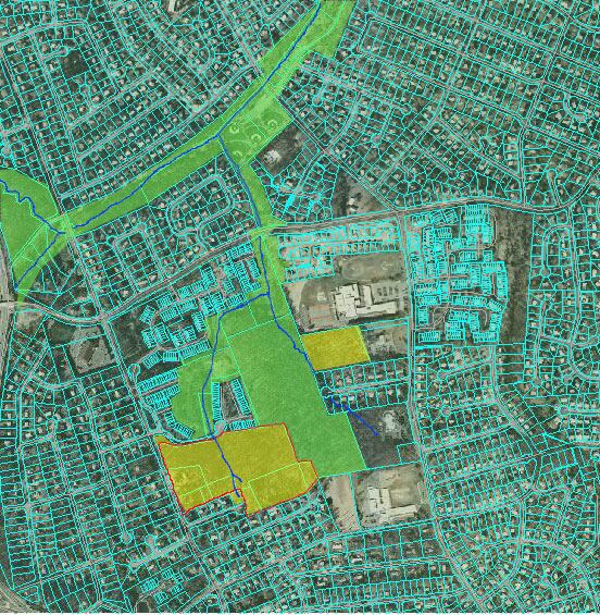
Aerial photo of Burke’s Spring Branch watershed and adjacent areas of Pimmit Run, taken from the Fairfax County aerial viewer. The streams are drawn in blue, and the proposed Winchester development is outlined in red. Green shading indicates currently protected land (parks and open space held by homeowners’ associations) that meets at least two of the EQC criteria in Objective 9, policy a of the Environment section of the Comprehensive Plan (i.e. the land is a protected stream valley, exhibits “connectedness” with protected stream valleys, forms “part of a green belt separating land uses,” and/or helps to reduce nonpoint source pollution). Yellow shading indicates unprotected land that meets two or more of these criteria. In short, all of the land in the planned Winchester development has the potential to form part of the county EQC system; how much of it actually serves this function will depend on the extent to which the development is designed to preserve the connectedness of remaining habitat and the pollution reduction potential of the land.
|
||||||||||||||||||||||
| Home | Watershed Map & Areas of Interest/Concern |
Historic Watershed Maps | Activities | Contact/Join Us |
All items copyright © 2003-2005
Friends of Burke's Spring Branch unless another source is noted.
Copyright for items with identified authorship remains with the
author(s); historical and other documents reproduced here are, to
the best knowledge of the webmaster, in the public domain. Items
under Friends of Burke's Spring Branch copyright may be reproduced
for nonprofit research or educational use as long as this copyright
notice is included. Please direct comments and questions to Cathy
Saunders. |