| Historic
Watershed Maps |
|
| Activities |
|
| you are here: home > historic watershed maps > bsb waterhsed during civil war | |
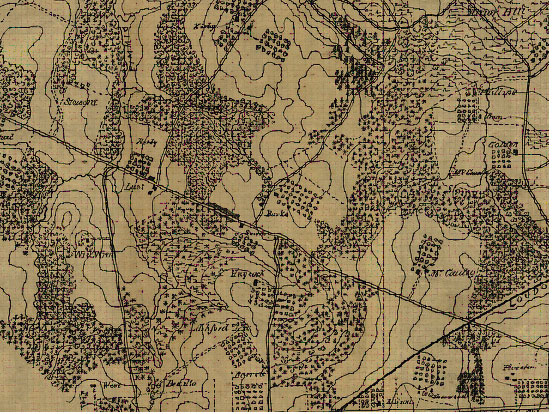
The image below is taken from a map in the Library of Congress American Memory collection entitled "Detailed map of part of Virginia from Alexandria to the Potomac River above Washington, D.C. 186-." The whole map can be viewed online, at much higher resolution, at http://hdl.loc.gov/loc.gmd/g3883a.cw0523000 . The area shown here is in the top center of the lower left-hand panel. In the image below, you can see the Burke farm at the center, with Great Falls St. immediately below, Kirby Rd. running by the two Kirby properties on the left, and Pimmit (labeled "Pimmic") Run to the left of the Kirby properties. A road running from Great Falls St. through the Burke farm continues on to Minor's Hill, where there was a large Union encampment; this road, a continuation of the original driveway into the Burke Farm (which was located just north of present-day Crutchfield St.), seems to have existed in its entirety only during the Civil War, and confirms the Burke family's account that the soldiers encamped at Minor's Hill made frequent trips through their property while performing picket duty and gathering supplies. These supplies included, according to the Burkes' later claim for damages, potatoes and corn from their fields, and chestnut fence rails, which the soldiers took down and used for fuel, and also, according to the testimony of neighbor James E. Kirby, "carried. . .by hand to the picket line" which "they established. . .along the road in front of Mrs. Burke's farm," the present-day Great Falls St. (the smudgy lines along Great Falls St. just north of the Burke farm driveway may be in some way associated with this picket line; I have not so far been able to figure out what they're intended to symbolize). Two square outlines indicating structures are shown on the Burke property; the lower one (above and slightly to the left of the "B" in Burke) is probably the barn, while the second (straight up from the "r" in "Burke") is probably the Dye/Burke house, since the relative locations of the buildings match up with those shown in the 1902 survey of the property. The orderly rows of symbols on the Burke property and elsewhere indicate orchards. Both forks of Burke's Spring Branch are visible in this picture, with the western fork surrounded by trees in what is otherwise a cleared area. Its location is not perfectly correct; it should be a bit lower, following the land contour that points toward the barn. Such minor errors are not unusual in maps of this era; the Burke orchard shows up in slightly different locations on the hill that now hosts the FAA towers on the various Civil-War-era maps that survive. Cartographers of this era do, however, agree on the basic, two-forked, shape of the Branch, even when they do not locate the headwaters of each fork precisely. Note: this map is oriented with its top approximately toward the northeast, not the north.
|
|
| Home | Watershed Map & Areas of Interest/Concern |
Historic Watershed Maps | Activities | Contact/Join Us |
All items copyright © 2003-2005
Friends of Burke's Spring Branch unless another source is noted.
Copyright for items with identified authorship remains with the
author(s); historical and other documents reproduced here are, to
the best knowledge of the webmaster, in the public domain. Items
under Friends of Burke's Spring Branch copyright may be reproduced
for nonprofit research or educational use as long as this copyright
notice is included. Please direct comments and questions to Cathy
Saunders. |