| Historic
Watershed Maps |
|||||||||||||||||||||||||||||||
| Activities |
|||||||||||||||||||||||||||||||
|
|||||||||||||||||||||||||||||||
| you are here: home > watershed map & areas of interest/concern | |
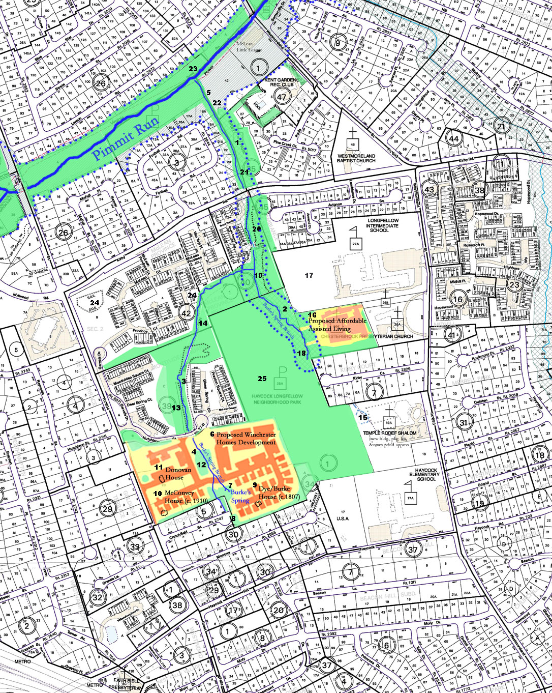
A watershed is the area of land that drains into a particular body of water. Watersheds are nested; for instance, the Burke's Spring Branch watershed is part of the Pimmit Run watershed, which in turn is part of the Potomac River and Chesapeake Bay watersheds. The dividing line between two watersheds is usually a high point, with the water flowing in different directions on either side. However, since high points aren't always arranged in an even way around water bodies, and water flows underground as well as overground, the exact boundaries of a watershed, even in its natural state, aren't easy to determine. Tracing the flow of water gets even more complicated when humans build structures such as stormwater ditches, pipes and ponds. We know that the great majority of the land on the Haycock-Longfellow block (bounded by Great Falls St., Kirby Rd., Westmoreland St., and Haycock Rd.) drains into Burke's Spring Branch, as do areas to the north that slope toward the stream. Some small areas to the west of Great Falls St. and to the east of Westmoreland also drain into Burke's Spring Branch, as do some neighborhoods to the south of Haycock, especially those nearer Great Falls St. Other areas shown on this map drain directly into Pimmit Run, into the Pimmit Run tributaries to the west and east -- Darne's Spring/Bridge Branch and Darrell Branch -- or into tributaries of Four Mile Run, the next large Potomac tributary to the south. The stream is shown in blue on
the map below. The rows of blue dots indicate the limits of RPA
(resource protection area), a 100-foot vegetated buffer surrounding
perennial streams that may not be disturbed by development or other
activities. (One of our major concerns is that the western branch
of Burke's Spring Branch, and Burke's
Spring itself, have not been recognized by Fairfax County as
perennial, and protected by RPA; see EQAC testimony
for details and the account
of an Oct. 2005 incident of erosion and sedimentation from the Stockwell
Manor site for one likely consequence). The green shading on the
map indicates areas that are protected by inclusion in a park, RPA,
and/or present or projected open space in a development. Yellow-shaded
areas indicate the planned limits of clearing and grading in two
dvelopments that are planned or in process, one by Camberley Homes
(a division of Winchester Homes, which originally proposed the development),
and one by Chesterbrook Residences, Inc. (a nonprofit formed by
a coalition of local churches). Orange-shaded areas indicated proposed
additions of impervious surface (pavement & roofs) in those
developments.
|
|
| Home | Watershed Map & Areas of Interest/Concern |
Historic Watershed Maps | Activities | Contact/Join Us |
All items copyright © 2003-2005
Friends of Burke's Spring Branch unless another source is noted.
Copyright for items with identified authorship remains with the
author(s); historical and other documents reproduced here are, to
the best knowledge of the webmaster, in the public domain. Items
under Friends of Burke's Spring Branch copyright may be reproduced
for nonprofit research or educational use as long as this copyright
notice is included. Please direct comments and questions to Cathy
Saunders. |