FOBSB Dec. 2003 EQAC Testimony
| Historic
Watershed Maps |
|
| Activities |
|
| you are here: home > activities > letters > FOBSB Dec. 2003 EQAC testimony | |
Friends
of Burke’s Spring Branch
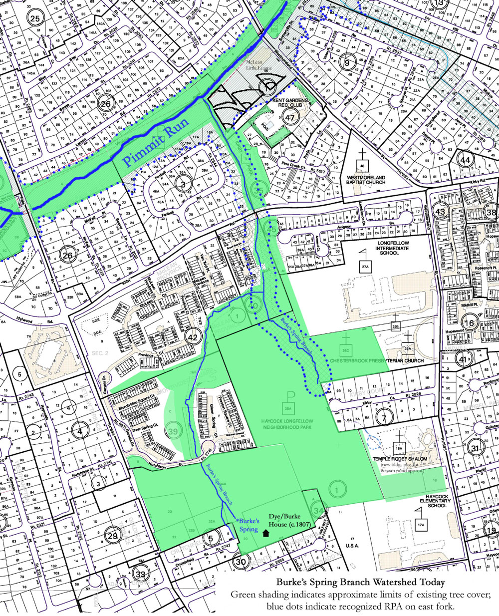
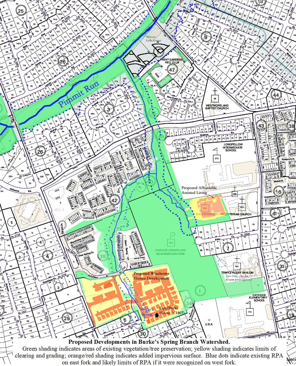
Concerns About the Present and Future State of our Local Watershed (Testimony before the Fairfax County Environmental Quality Advisory Council, 12/2/2003) Burke’s Spring Branch is a tributary of Pimmit Run located in the area of Fairfax County between downtown McLean and the City of Falls Church , primarily on the block containing Haycock and Longfellow schools and the Haycock/Longfellow Neighborhood Park. As the Branch’s name suggests, its historic origin is a spring located just northeast of what is now the foot of Crutchfield St, known as Cockerill’s Spring in the 18th century, and Burke’s Spring since the early 19th century. Since sometime in the mid-20th century, this western fork of the Branch has also been fed by a series of concreted and piped stormwater drainage channels handling runoff from approximately 30 upstream acres. A second, eastern, fork, historically originating in springs on what is now the Temple Rodef Shalom property, and now originating in a stormwater pond on that property, flows through Haycock-Longfellow Park, and joins the western fork on the common property of Brooks Square. From there, the Branch flows under Kirby Rd., through Kirby Park and along the border of the McLean Little League before joining Pimmit Run about 500 ft. upstream of Westmoreland St. (see attached maps). The eastern fork of Burke’s Spring Branch and the portion of the Branch below the confluence were recognized as perennial during Fairfax County’s recent Stream Survey, and have received RPA protection. This protection has already played a useful role in assuring that both the stream and the park receive as much buffering as possible from an affordable assisted living facility projected for a 5-acre parcel on the eastern fork. The upper reaches of the western fork, because they disappear during times of low flow into a shale bed and hence, presumably, to an underground stream, were missed by a stream survey team working its way upstream from Pimmit Run. A resurvey, resulting in a borderline score of 24, was performed too late for the reach to be included in the stream survey maps approved by the Fairfax County Supervisors in Nov. 2003. This reach is now the subject of a quality control study, a study that will provide valuable insight into how the County’s assessment protocols can best be applied to small headwaters streams. Reconsideration of the perenniality of the western fork of the stream is especially important because Winchester Homes is proposing a PDH-5 development for the 21 acres of now-wooded land surrounding the upper reach of this fork. Because this reach currently lacks an RPA, Winchester has been able to propose placing a road directly over Burke’s Spring. We hope that EQAC will help us protect our local watershed by joining us in advocating the following: 1. Recognition that the western reaches of Burke’s Spring Branch, and the spring itself, are perennial, and deserve corresponding protection. --The naming of the spring, the existence of the remains of a springhouse at the spring site, the spring’s proximity to the c. 1807 Dye/Burke house, located east of the foot of Crutchfield St., and the spring’s status as a valuable inheritance in the 19th and early 20th centuries all suggest perenniality. --Longtime residents of the neighborhood have no memory of the spring, or the reach stemming from it, drying up, even in drought years. --Volunteer monitoring of the benthic macroinvertebrate population in the Branch in Nov. 2003 (see attached results) found a number of species in the western reaches, including clams and Trichoptera (caddisflies), which are mentioned in both Fairfax County’s “Perennial Stream Field Identification Protocal” and the Chesapeake Bay Local Assistance Department’s “Guidance on the Chesapeake Bay Preservation Area and Management Regulations” as potential indicators of perenniality. The overall population numbers were also high relative to those in the recognized perennial reaches – another likely indicator of perenniality. Professional identification below the Order level used for biological monitoring may be necessary to determine the significance of benthic macroinvertebrates for determining perenniality; the samples have been saved in case such identification would be helpful. Fish – another indicator of perenniality, particularly given the barriers to their upstream movement on the western reaches -- have also been sighted in these reaches. 2. Preservation of existing woodland in locations that will make it most useful to wildlife, both terrestrial and aquatic, and most effective in filtering stormwater. --As the County Comprehensive Plan recognizes, stream valleys form the core of an EQC system that provides filtering for stormwater, and connected sections of habitat for wildlife. --The existing layered woodland and the humus layer it has built are far more effective in filtering stormwater than replacement “green” or “open” space consisting of sod or other vegetation planted on recently-graded soil would be. Therefore, we believe that as much of the open space as possible on the Winchester Homes development should consist of preserved existing woodland. --The common land owned by other communities in the neighborhood, including McLean Greens, McLean Province, and Brooks Square, is located so as to buffer Burke’s Spring Branch and Haycock-Longfellow Park, and to preserve contiguity with habitat provided by protected land in Kirby Park and along Pimmit Run. Such arrangement of open space also helps preserve a critical mass of habitat for species with relatively large ranges, such as Pileated Woodpeckers and Box Turtles (both frequently sighted in the area), and makes it possible to preserve some dead and dying trees as nesting and feeding sites without endangering people or houses. We believe that open space on the Winchester Homes development would be most valuable ecologically if it followed this model. A development plan that respected RPA and EQC, either at the behest of the County or voluntarily, would be a step in this direction. --As a headwaters stream, Burke’s Spring Branch also plays a vital role in the aquatic food chain by supporting organisms that break down vegetative matter and make its energy available for use by larger organisms. Since much of this vegetative matter consists of fallen leaves and twigs, preservation of tree cover is vital to preserving the stream’s role in the the aquatic food chain. --Monitoring of both Burke’s Spring Branch and a site on Pimmit Run immediately downstream of Burke’s Spring Branch have shown significant impairment, with habitat scores ranging from the low to the high end of “unacceptable” on the Virginia Save Our Streams multimetric index. The difficulty in finding a full, 200-organism sample in the recognized perennial reaches is another indicator of low habitat quality. In order to preserve the health of the entire Chesapeake Bay watershed, and to meet the requirements of the Chesapeake Bay Preservation Ordinance, we need to preserve and, if possible, improve the health of tributary streams. --Severe erosion in the area of stormwater outfalls below Crutchfield St and Kirby Ct., and the persistent presence of standing water in what are designed to be infiltration areas on Brooks Square’s common land, suggest that inadequately mitigated runoff is one of the major stressors affecting the health of the stream. --Both Winchester Homes and the committee proposing the Chesterbrook Affordable Assisted Living Facility have expressed tentative interest in using LID practices such as raingardens and pervious pavement on their sites. They have also each proposed some potential mitigation of existing problems: 10% overrention in the case of the Chesterbrook committee, and reworking of the concrete stormwater channel at the base of Crutchfield St. in the case of Winchester Homes. We hope EQAC and county staff will join us in urging them to pursue these possibilities vigorously, and to think in terms of taking measure to improve the health of the stream rather than merely maintaining its present impaired status. 4. Encouraging Winchester Homes to preserve Burke’s Spring as a reminder of local history and of human beings’ continuing need for clean water. --Burke’s Spring has played a role in shaping humans’ use of land in its watershed at least since colonial days. The presence of the springhouse and the location of the Dye/Burke house are reminders of that fact. We understand that Winchester Homes’ archeological consultants also found some evidence of Native American activity along the stream, and we suspect that Civil War soldiers, who moved repeatedly through the area, would have camped near it as well. --Because of this history, Burke’s Spring is an important reminder that clean water is vital to sustaining human life. This fact is easily forgotten thanks to modern day water purification and distribution systems, but it is a fact nevertheless, and our tributary streams continue to play a role in supplying our drinking water. --Burke’s Spring’s history, and its role as a reminder of the role of water in human history and modern-day life, deserve to be recognized through thoughtful incorporation of the spring and the remaining foundation of the spring house into the common land of the Winchester Homes development. Additional reminders of the spring’s importance, such as an interpretive plaque or the naming of a nearby street for the spring, may be appropriate. (We would, however, adamantly oppose naming any road that runs over the spring, or that violates RPA, for the spring, or for any other natural feature.) Submitted for FOBSB by Cathy Saunders
Written testimony also included the chart giving results from our first round of monitoring. |
|
| Home | Watershed Map & Areas of Interest/Concern |
Historic Watershed Maps | Activities | Contact/Join Us |
All items copyright © 2003-2005
Friends of Burke's Spring Branch unless another source is noted.
Copyright for items with identified authorship remains with the
author(s); historical and other documents reproduced here are, to
the best knowledge of the webmaster, in the public domain. Items
under Friends of Burke's Spring Branch copyright may be reproduced
for nonprofit research or educational use as long as this copyright
notice is included. Please direct comments and questions to Cathy
Saunders. |