| Historic
Watershed Maps |
|
| Activities |
|
| you are here: home > historic watershed maps > 1902 division of Burke Farm | |
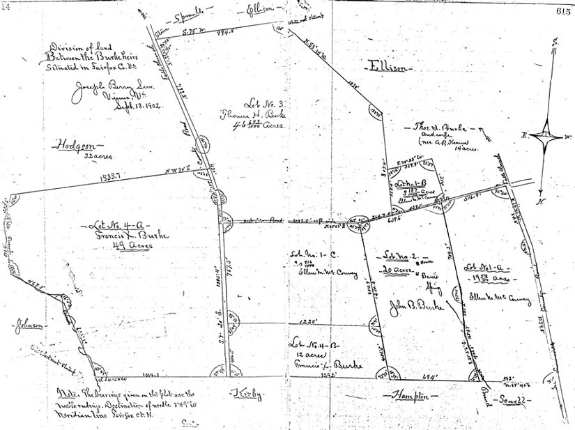
This survey of the Burke Farm, conducted when the land was divided among the Burke heirs in 1902, appears in Fairfax County Deed Book K6, pp. 614 & 615. The farm occupied the southern third of what is now the Haycock-Longfellow block (ending at a line that runs along the southern boundary of the present McLean Greens property, though Haycock/Longfellow park, and along the northern boundary of the Temple Rodef Shalom property), plus considerable land to the south and east. The road at the far right of the survey, labeled "Lewinsville County Road," is the present-day Great Falls St.; Haycock Rd. and Westmoreland St. are also present in what appear to be their current locations. Natural features are also used as landmarks; there are notes indicating the location of a "white oak stump" (at the top, in the middle) and an "old chestnut stump" (lower left) and both Darrell Branch (at the bottom left, between lot 4-A and the Johnson property) and Burke's Spring Branch (at the lower right, between lots 1-A and 2) serve as property boundaries. On the John B. Burke property in the lower right, the surveyor has marked the locations of the Dye-Burke house, its barn (demolished in the 1920s to provide wood to repair the house) and Burke's Spring , and has carefully delineated the fork leading from Burke's Spring to the main channel of Burke's Spring Branch. Lot 1-A, inherited by Ellen McConvey, would later become the site of the c. 1910 McConvey and c. 1925 Donovan houses. (Thanks to Mark Zetts, who provided the copy from which this image was scanned, and to Cecile Glendening, who looked up the deed book reference.)
|
|
| Home | Watershed Map & Areas of Interest/Concern |
Historic Watershed Maps | Activities | Contact/Join Us |
All items copyright © 2003-2005
Friends of Burke's Spring Branch unless another source is noted.
Copyright for items with identified authorship remains with the
author(s); historical and other documents reproduced here are, to
the best knowledge of the webmaster, in the public domain. Items
under Friends of Burke's Spring Branch copyright may be reproduced
for nonprofit research or educational use as long as this copyright
notice is included. Please direct comments and questions to Cathy
Saunders. |