
| Historic
Watershed Maps |
|
| Activities |
|
| you are here: home > areas of interest/concern > Dye/Burke House | |
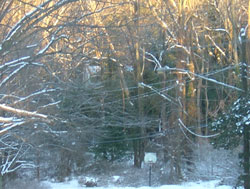
The Dye/Burke House, just visible through the woods at the foot of Crutchfield St. in the picture above, was most likely located to take advantage of the nearby spring, which served as a source of water and refrigeration for residents of the house. While we have yet to find any document pinning down the exact date of the house's construction, we know from Fairfax County deed book records that in 1808 Reuben Dye bought 209 acres of land from Philip Darrell, and believe that he moved with his family to the land soon after. He was certainly living there, with his wife, two children, and five slaves, by the time of the 1810 census. When he died in Nov. 1815, the Alexandria Gazette noted that "his friends and acquaintances are respectfully invited to attend his funeral from his late dwelling at the Falls Church"; this may well be the first recorded reference to the house. Oral tradition offers additional support for the idea that the house dates at least to the early 19th century. As Melvin Steadman records in his 1964 Falls Church by Fence and Fireside, the house was for many years known as "Royal Lodge" because "a story told by old residents" identified it as "a hunting lodge of a Royal Governor of Virginia" (281). While it is unlikely that this story is true -- according to research done by Kathy Frase, a member of the family that currently owns the house, "there was no house on [the Darrell] tract" when Reuben Dye bought it -- it does suggest that its mid-20th-century neighbors were aware that the house was one of the oldest in the area, dating to well before their own lifetimes. After Reuben Dye's death, his widow Elizabeth operated the farm for 17 years, then sold it to John Burke, an Irish immigrant, in 1832. John Burke died in 1858, and his widow, Mary Ann, and their children carried on the farm. During the Burkes' occupancy, the farm supported a variety of livestock (horses, milk cows, sheep, and hogs, acccording to the 1860 Fairfax agricultural census) and produced butter and a variety of crops including hay, oats, corn, and potatoes. By the time of the Civil War, buildings on the property included a barn or "stable" and springhouse (both mentioned in Mary Burke's postwar claim for damages to the Federal Government) as well as the house, which served as a headquarters for the officers of the reserve pickets during the winter of 1861-62. Maps from this era show the house in its present location, as well as the barn, stream, cleared fields, an orchard, and a driveway connecting to what is now Great Falls St. During this period, according to James Kirby's testimony before the Southern Claims Commission, Union soldiers "established the picket-line along the road in front of Mrs. Burke's farm including Mrs. Burke's farm within the Union lines." This road was heavily used by both Union and Confederate troops (including Mosby's raiders) travelling between Falls Church and Lewinsville throughout the war. During 1861 and 1862, there was also considerable movement between the Burke farm and Minor's Hill, where a number of Union regiments were encamped. As Mary Ann Burke's southern claim records, soldiers from Minor's Hill subsisted in part on potatoes stolen from her fields, with chestnut fence rails from the Burke farm serving as fuel. The Burke farm remained intact until 1902, when Mary Ann Burke died and the land was divided among her children (see survey). John B. Burke, who inherited the house, barn, spring house and 20 surrounding acres, died in 1904. His son, Francis X. Burke, inherited the house, outbuildings, and 4 acres. In 1907, Francis Burke's widow sold the property to the first of a succession of owners who held the property briefly during the first quarter of the 20th century. In 1925, John and Ida Stoddard bought the property and embarked on an extensive renovation, removing a wooden kitchen that had been added to one end of the house, building their own substantial addition onto the back, and replacing the beams below the first floor with ones from the barn (which was torn down for this purpose). In addition, they raised the original roof line, combined several dormers into a single one, added a porch and some windows, enlarged other windows, and cemented over the original brick exterior. In 1941, Robert W. and Eleanor Stockwell Frase bought the house, and, over a period of time, 18 surrounding acres. They raised three children in the house, and lived there until December 2002. The Dye/Burke house and over 20 surrounding acres (once farmland, returned over the course of the 20th century to their original wooded state) are now under contract to Winchester Homes, which is planning a 102-unit development (to be named Stockwell Manor in honor of Eleanor Stockwell Frase). Unfortunately, Winchester's current plans call for the demolition of the Dye/Burke house, now approaching 200 years old. While the exterior of the house has been substantially altered, it still has much to teach about the early history of our area. Its location near the spring is a reminder of the importance of such resources, both for water and for refrigeration, to 19th-century farmers. Its original size, clearly visible from the front, indicates the relatively modest scale on which early-19th-century Fairfax County farmers, even those wealthy enough to own 200 acres and several slaves, lived. The footprint of the now-removed kitchen addition can also be identified, and the Stoddard's 20th-century addition and alterations are still present, making it possible to trace two centuries of changes to the house. The house can also be compared to the McConvey house, now at 2119 Great Falls St. (and also scheduled to be demolished by Winchester Homes) built by Burke descendants in the early 20th century. A thorough archeological investigation of the property would undoubtedly reveal additional information: the materials from which the house is made (a combination of local and European brick, according to Kathy Frase); the uses of the spring by residents of the Dye/Burke house and possibly, at an earlier time, by Native Americans (who may also have been attracted to the vein of quartz that runs through the property); and the locations of the barn, orchard, and a family graveyard (emptied of Burke remains in the 20th century, but possibly still holding the remains of slaves). In order to fulfill county requirements for the documentation of "heritage resources," Winchester Homes needs to complete such an investigation before they begin the process of demolition, clearing, and grading. Ideally, we'd like to see them incorporate the Dye/Burke house -- which, though in need of renovation (as it was in the early 20th century) is apparently sound and habitable -- into the development, so that this piece of local history can be preserved.
Note: for more information about Mary Burke's southern claim, Kathy Frase's article, and other sources mentioned on this page, please see the links & sources page. |
|
| Home | Watershed Map & Areas of Interest/Concern |
Historic Watershed Maps | Activities | Contact/Join Us |
All items copyright © 2003-2005
Friends of Burke's Spring Branch unless another source is noted.
Copyright for items with identified authorship remains with the
author(s); historical and other documents reproduced here are, to
the best knowledge of the webmaster, in the public domain. Items
under Friends of Burke's Spring Branch copyright may be reproduced
for nonprofit research or educational use as long as this copyright
notice is included. Please direct comments and questions to Cathy
Saunders. |