| Historic
Watershed Maps |
|
| Activities |
|
| you are here: home > areas of interest/concern > CAALF site | |
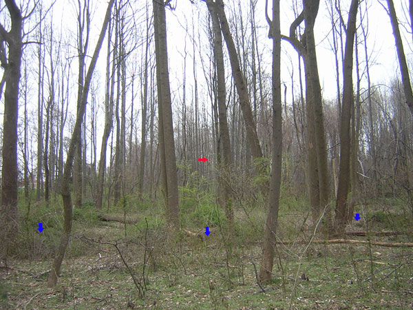
Note: there have been changes to the CRI site plan (requested by the County site reviewers in order to achieve what is called adequate outfall) that will affect not only the stream but also adjacent trees, including some on parkland. A copy of the current plan for the stream is available here ; we will update this page as soon as we learn more. Note: When this project was first proposed, it was called Chesterbrook Affordable Assisted Living Facility (CAALF). You'll see references to that name below and elsewhere on this site; the project is the same. The Chesterbrook Affordable Assisted Living Facility (CAALF) is a 109-bed residence that a coalition of local congregations proposes to build on a currently-wooded 5-acre parcel behind Chesterbrook Taiwanese Presbyterian Church (2030 Westmoreland St.) and immediately adjacent to Burke's Spring Branch, which runs for some distance along the boundary between Haycock/Longfellow Park and the western boundary of the CAALF site. The site also adjoins the rear yards of homes on Kirby Ct. to the south, and Longfellow School to the north. In its current natural state, this parcel helps to protect the stream by slowing and filtering runoff, and by providing for transpiration and gradual infiltration of rainwater. Any transformation of woodland to impervious surface in the watershed, and especially on parcels which, like this one, immediately adjoin Burke's Spring Branch, will further stress the already-impaired stream. Unfortunately, this parcel is unlikely to remain in its current state; if the proposed assisted living facility is not built, a by-right development of 10 homes is the most likely alternative. The assisted living facility has some ecological advantages over such a development: it will create less impervious surface than 10 homes and the associated roads and driveways would, and, because there must be a 100-foot buffer between a medical facility and its neighbors, more of the existing woodland will be preserved. The committee proposing the facility has also promised to build a stormwater pond 10% larger than required, and has expressed a willingness to consider measures for preserving and enhancing habitat on the property. Nevertheless, major concerns with this development remain, including its visibility from the park (which will be screened primarily by the 100-foot RPA along the stream) and adjoining neighborhoods, the adequacy of stormwater control measures (which, despite county-approved planning, have not proven adequate on other recent projects in the watershed, including the Temple Rodef Shalom addition, upstream on the same channel), and its potential impacts on traffic, pedestrian safety, and the residential character of the neighborhood. Neighbors have expressed their concerns (and some qualified support) for this development in letters and testimony, which you can read on this website. You'll also find additional information about CAALF on the official website put up by the the committee planning the facility, http://www.chesterbrookres.org/. The picture below shows the Chesterbrook site as seen from the path in Haycock/Longfellow Park. Longfellow School is just visible through the trees at the far left in the picture. A red arrow points to a red mylar balloon which I believe marks the proposed location and height of northwest corner of the facility. Current plans call for clearing another 100 feet beyond this point (to allow room for the stormwater pond and sewer access) with some replanted landscaping close to the building, and 75-100 feet of preserved woodland on the southern boundary along Kirby Ct. (to the right and partly out of sight in this picture). The location of the stream (the channel of which is quite deeply incised by erosion, and somewhat hidden by shrubs in this picture) is indicated by blue arrows; the easiest place to spot its exact location is in the center of the picture, where you can see the exposed roots of a tree that was growing along the streambank, but, thanks to erosion, has recently fallen over. At this point, the stream runs near the property boundary between the park and the CAALF site; to get a better sense of the relative locations of the park, stream, CAALF site, and proposed building, please consult the watershed map.
|
|
| Home | Watershed Map & Areas of Interest/Concern |
Historic Watershed Maps | Activities | Contact/Join Us |
All items copyright © 2003-2005
Friends of Burke's Spring Branch unless another source is noted.
Copyright for items with identified authorship remains with the
author(s); historical and other documents reproduced here are, to
the best knowledge of the webmaster, in the public domain. Items
under Friends of Burke's Spring Branch copyright may be reproduced
for nonprofit research or educational use as long as this copyright
notice is included. Please direct comments and questions to Cathy
Saunders. |