| Historic
Watershed Maps |
|
| Activities |
|
| you are here: home >areas of interest/concern > Burke's Spring > Winchester Plan | |
Update
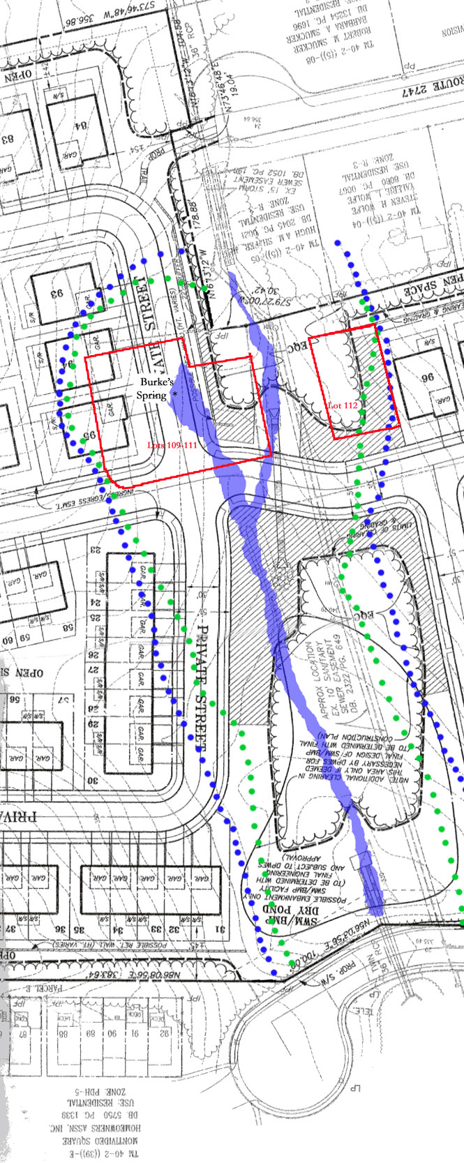
to information on this page Winchester Homes' current plan for the stream and the area surrounding the spring is shown below. The underlying black and white image is taken from the 12/15/03 version of plans for the Stockwell Manor development submitted by Winchester Homes to Fairfax County as part of its rezoning application (it is now slightly outdated -- the shapes of the stormwater pond and tree preservation area have changed just a bit -- but the basic handling of, and threats to, the stream, spring, and surrounding vegetation remain the same). The colored portions are an overlay showing the stream (solid blue) as delineated on another page of the plan, my own attempt to delineate the approximate limits of RPA (resource protection area -- the blue dots) and EQC (environmental quality corridor -- the green dots), and the location of lots 109-112 on an earlier, 6/3/03, version of Winchester's plan reviewed by a conservationist with the Northern Virginia Soil and Water Conservation District (red lines and labels). RPA is an 100-foot area on either side of a perennial stream that cannot be disturbed during development except to construct structures that absolutely must be located in that area (such as road crossings perpendicular to a stream). Because this section of Burke's Spring Branch has not yet been recognized by the county as perennial (see EQAC testimony and discussion of McLean Greens to confluence reach for more details), it has not received RPA. We were told during the resurvey of the stream this fall that even if the stream did not receive RPA, it would be eligible for EQC, a smaller protected area defined by Objective 9, policy a of the Environment section of the Fairfax County Comprehensive Plan as including "all the land within a corridor defined by a boundary line which is 50 feet plus 4 additional feet for each % slope measured perpendicular to the stream bank." As you can see below, Winchester Homes has designated some areas on the plan as EQC, but they aren't nearly as extensive as described in the Comprehensive Plan. We have a number of concerns about this plan. The first is the planned burial of Burke's Spring, the historic headwaters of Burke's Spring Branch, underneath a road. While this may be feasible from an engineering point of view, it would represent a real loss in historical and environmental terms. As a Northern Virginia Soil and Water Conservation District Conservationist noted in a memo reviewing the plan, "Lots 109-112. . . .have a great deal to offer in leaving the area intact and in the native state." While Winchester has removed homes from these lots in its current version of the plan, neither the road planned for much of the former lots 109-111 -- the location of the spring -- nor the cleared, graded, and replanted "habitat enhancement area" planned for the former lot 112 qualifies as keeping the area "intact and in the native state." We are also concerned to see so much impervious surface -- in this case, pavement -- located not only over the spring itself, but in other areas close to the stream. Because rain hitting impervious surfaces runs off much more quickly than does rain falling on undisturbed woodland, every addition of impervious surface in a stream's watershed increases the danger of erosion. Impervious surface also prevents infiltration (the natural seeping of rainfall into the ground) and thus robs streams of groundwater recharge (the slow, steady seeping of water into the stream from its bottom and sides, which, unlike sudden runoff from impervious surfaces, does not cause erosion). While one road crossing the stream is necessary to develop the majority of the land included in Stockwell Manor, roads parallel to the stream can and should be located outside of RPA and/or EQC. The NVWSCD reviewer noted that "the property currently has large trees that protect the area from a conservation standpoint"; we'd like to see as many of these trees (and the vegetation and humus layers that accompany them) preserved as possible, especially in areas adjacent to the stream. Another major concern is the plan to pipe the section of the stream that runs under the proposed new road. Hard-walled structures such as pipes and concrete-lined channels speed the flow of water through them, producing a "firehose" effect that can exacerbate downstream erosion. Winchester has made a commitment in their most recent proffers to replace the concrete-lined stormwater channels on the Shafer/Wolfe property with a rip-rap ditch (subject, of course, to owners' approval). This approach would slow the flow of water from the pipes and channels further upstream, and thus improve the health of the stream. However, much of the good done by reconstructing the channels could be lost if an almost equal amount of natural streambed is replaced by a pipe. One solution would be to construct a bridge to carry the road over the stream, allowing the natural streambed to remain. Finally, we should note some areas in which we are in at least partial agreement with Winchester. We are glad they plan to construct an embankment-only stormwater facility, which will require considerably less clearing than a traditional facility, since the largest rainfalls will be allowed to back up into an area of preserved woodland. We are somewhat concerned by the large overlap between this "tree preservation area" (inside the dotted lines indicating limits of clearing and grading) and an area labeled "additional clearing in this area only if deemed necessary by DPWES for final design of SWM/BMP," since it seems that a great many more trees than currently indicated might be lost, but we agree in principle that this is the best approach to this area, and are glad to see that the commitment in the proffers to saving trees in this area is becoming increasingly specific. We also appreciate Winchester's willingness to replant the crosshatched "habitat enhancement areas" with plants native to the area, to plant native trees in buffer areas, and to develop a removal plan for invasive alien species. We'd like to see more attention to using species already prevalent in the area, to preserving the local genetic pool by transplanting plants from the areas to be cleared, and to ongoing monitoring of alien species (which tend to spring up repeatedly in disturbed areas). We'd also like to see Winchester consider using native trees as street trees.
|
|
| Home | Watershed Map & Areas of Interest/Concern |
Historic Watershed Maps | Activities | Contact/Join Us |
All items copyright © 2003-2005
Friends of Burke's Spring Branch unless another source is noted.
Copyright for items with identified authorship remains with the
author(s); historical and other documents reproduced here are, to
the best knowledge of the webmaster, in the public domain. Items
under Friends of Burke's Spring Branch copyright may be reproduced
for nonprofit research or educational use as long as this copyright
notice is included. Please direct comments and questions to Cathy
Saunders. |